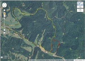
When I was about 14 years old, I was hunting on our 93-acre farm by myself. My father had told me that in orrder to best hunt a particular hill, I should follow the ridge line up, then when I got to the top, veer off to the right, and I would end up behind our house. It should only take me about two hours to slowly work my way through the area. Simple….

Click to Enlarge
….Five hours later, I finally stumbled into our yard, tired, worn, out, hungry, and pissed at the old man for sending me the wrong way. Somehow I ended up about three miles away from home on the wrong side of a steep ridge. I’m still perplexed to this day as to how I got turned around, but I’ve since proven to myself that it was me, and not dad’s directions. I’ve done this by looking over maps, both paper and now electronic ones.
Understanding the lay of the land you are in is an important skills, no matter if you are in a dense metropolitan area, or a secluded hilltops miles from the nearest town. Know where things are simply makes moving around easier, showing alternative routes to take, things to avoid, and for the explorer in you, things to go and see.
I currently live in a place with water on all sides of me, much of it impassable for one reason or another. This forces roads to travel in odd directions, making traffic flow unusual at best. I tell folks that if you are in Jensen Beach, either you intended to be here, or you are lost – nobody that knows the roads that are available travels through Jensen Beach, there are almost always better routes to take.
And maps are not just for driving. Fishing is a huge past time that causes me to look over maps for hours at a time. Looking for boat ramps, sand bars that would allow me to launch my kayak, distances to travel from a launch point to a hot fishing spot, are just some of the reasons I map gaze.
Google Maps is about as handy a map tool as I have found online. There are others, MapQuest, Rand McNally, Yahoo maps, etc (click here for a list of online maps and mapping tools), but I almost always default to Google Maps.
Look around your neighborhood, you’ll be amazed at the things around you you would never know was there. Use “Satellite” mode, as it shows off more of the terrain. I’ve looked around my area, and found two ponds within walking distance that I would never have known were there, as well as several patches of woods, probably chock-full of useful animal protein and wild edibles – handy information for when the zombie attack…
Maps are a portable representation of an area, and when used online, can be manipulated in some amazing ways…but those are for you to find, or for another post some day. Jump over and look around, you may be amazed!
I hope I didn’t lose you there…
db